| 714.82 KB | |
| 2008-04-21 13:40:06 | |
 | |
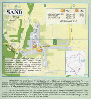
Nyilvános 2348 | 9071 | Sand | Somogy és Zala megye határán, távol a 7-es főút zajától, erdők, dombok övezte környezetben található Sand. A háborítatlan környezet és a környék gazdag vadállománya miatt kedvelt település. Első írásos említése 1372-ben: Sond. A településen ma 200 házban 535 lakos él. A falu gazdasági életében jelentős szerepet játszik a méhészet. Sand befindet sich an der Grenze der Komitate Somogy und Zala, weit vom Lärm der Hauptstraße Nr. 7., von Wäldern und Hügeln umgegeben. Sie ist wegen der ungestörten Umgebung und dem reichen Wildstand des Gebietes eine beliebte Siedlung. Ihre erste schriftliche Erwähnung ist in 1372 Sond. Auf der Siedlung leben heute in 200 Häuser 535 Einwohner. Im Wirtschaftsleben des Dorfes spielt die Bienenzucht eine wichtige Rolle. Sand is situated in an environment surrounded by forests and hills, far from the noise of the highroad Nr.7. on the border of Zala and Somogy Counties. Due to the peaceful environment and the rich wild-population the settlement is very popular. Its first written mention in 1372 is Sond. Now there are 535 inhabitants in 200 houses in the village. The bee-keeping plays an important role in the economic life of the villagers. A részlet a következő kiadványból származik/Die Teile stammen vom volgenden Buch/This text came from the following book: Cím/Titel/Title: Zala megye településeinek atlasza - 257 település részletes térképe/Atlas der Komitat Zala - 257 Detailte Siedlungskarten/Zala county\'s Atlas - 257 settlement maps. Közreműködő/contributor: Lackner László (1943) (fotó) Kiadás/Ausgabe/Publisher: Gyula : HISZI-MAP, 1997 Sorozat/Serie/Series: Indulástól - megérkezésig... ETO: 912(439.121-2) ; 908.439.121 Cutter: Z 19 ISBN: 963-610-025-4 Oldalszám/Seiten/Pages: 323, 81 p. Megjegyzés/Note: Lezárva/Abgeschlossen am/Closed am: 1997. máj. 30. |
